

Socio-economic context
A strong agricultural centre and a diverse social context
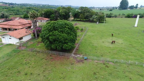
The Upper Paranapanema Basin is predominantly rural, with agriculture central to jobs and land value, and clear differences in economic and social conditions between municipalities.
Current situation
Research insights
Current situation
This is paragraph text. Click it or hit the Manage Text button to change the font, colour, size, format and more. To set up site-wide paragraph and title styles, go to Site Theme.
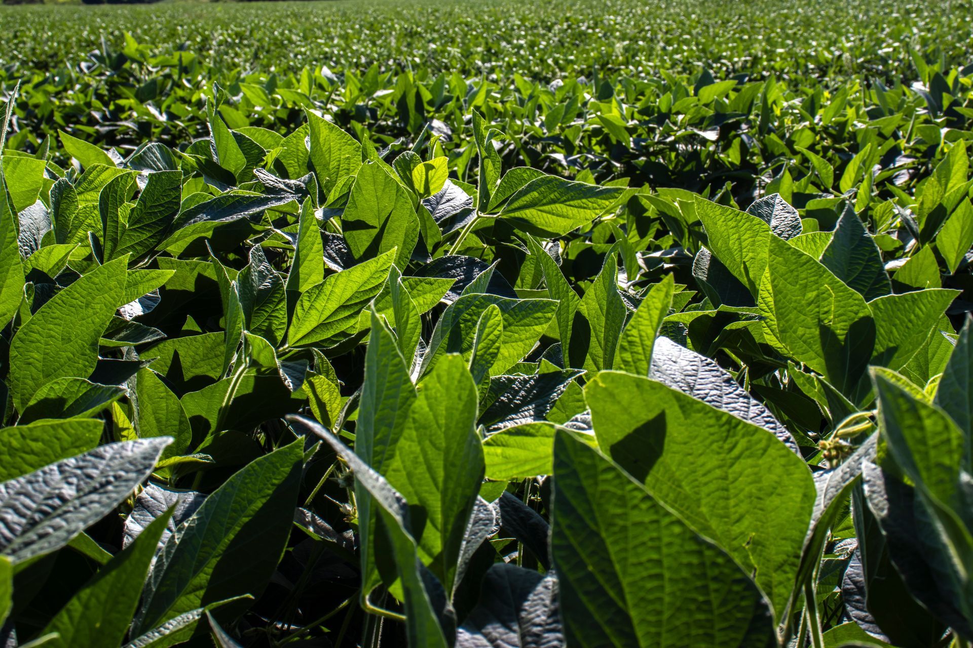
The region has one of the highest concentrations of center-pivot irrigation systems in São Paulo State, with 1,651 pivots identified in 2016, particularly in municipalities such as Itaí (the 11th highest concentration nationally), Itapeva, and Paranapanema.
Beyond agriculture, the basin supports industries related to paper and cellulose production, limestone mining, and timber processing. The region also holds significant tourism potential, particularly around the Jurumirim and Chavantes reservoir areas.
Economic situation
The Upper Paranapanema Basin is predominantly rural, with an economy that depends heavily on natural resources such as land and water. Although it covers just over 9% of São Paulo State’s territory, the basin generates less than 1% of the state’s total economic output.
Economic activity is unevenly distributed. More than half of the basin’s GDP is produced by a small number of municipalities, notably Itapetininga, Itapeva, Angatuba, Pilar do Sul and Capão Bonito.
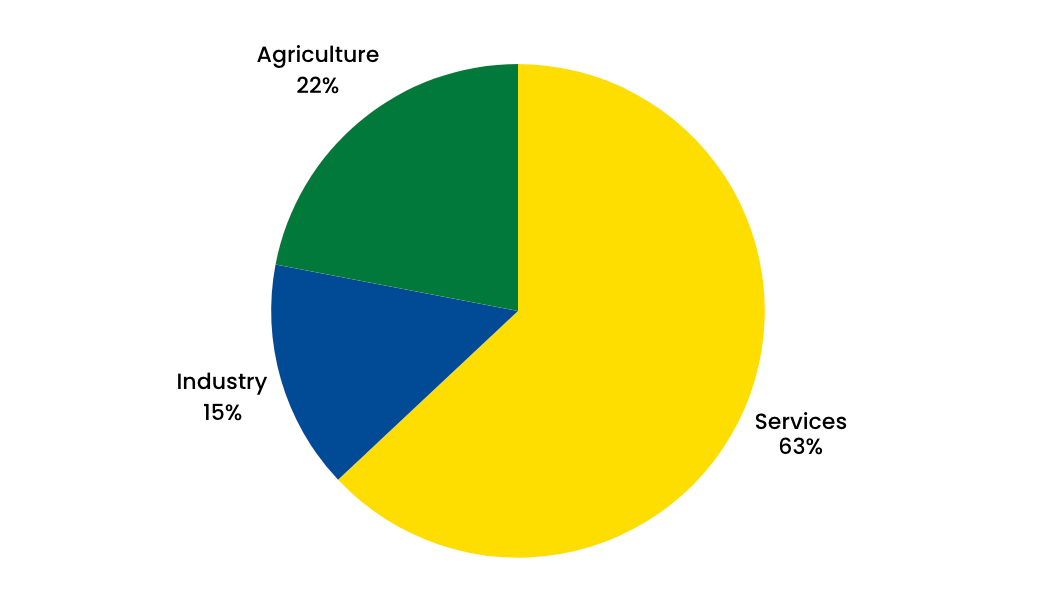
Agriculture plays a significantly larger role in the basin’s economy than it does statewide. While agriculture accounts for around 2% of value added across São Paulo State, in the Upper Paranapanema it contributes between 7% and 65% of municipal value added, depending on the municipality. Overall, the basin generates approximately 12% of the state’s agricultural value add.
Farming plays a major role in the economy in the Basin.
Agriculture dominates the economy in the Basin.
This is paragraph text. Click it or hit the Manage Text button to change the font, colour, size, format and more. To set up site-wide paragraph and title styles, go to Site Theme.
Sectoral contributions within the basin
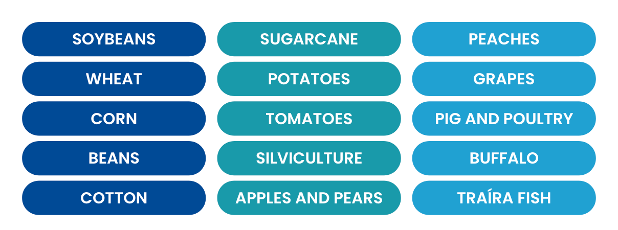
The basin is notable for the cultivation of the following crops:
Agriculture dominates the economy in the Basin.
This is paragraph text. Click it or hit the Manage Text button to change the font, colour, size, format and more. To set up site-wide paragraph and title styles, go to Site Theme.
The GDP per capita in the basin is around half of the GDP per capita across São Paulo state with Taquarivaí being the only municipality above the state GDP per capita.
The region has one of the highest concentrations of center-pivot irrigation systems in São Paulo State, with 1,651 pivots identified in 2016, particularly in municipalities such as Itaí (the 11th highest concentration nationally), Itapeva, and Paranapanema.
Beyond agriculture, the basin supports industries related to paper and cellulose production, limestone mining, and timber processing. The region also holds significant tourism potential, particularly around the Jurumirim and Chavantes reservoir areas.
Socio-cultural context
The Upper Paranapanema Basin is predominantly rural and agricultural. It comprises 34 municipalities with their administrative centres within the basin, as well as parts of a further ten municipalities.
In 2021, the basin had approximately 764,000 residents, representing less than 2% of São Paulo State’s population. Most municipalities have fewer than 30,000 inhabitants, and the four largest (Itapetininga, Itapeva, Capão Bonito and Itararé) together account for about 45% of the basin’s total population.
Livelihoods in the basin are closely linked to land and water use, with agriculture forming a central component of the local economy and daily life having historically shaped settlement patterns, family structures, and local labour markets, creating a strong rural cultural identity.
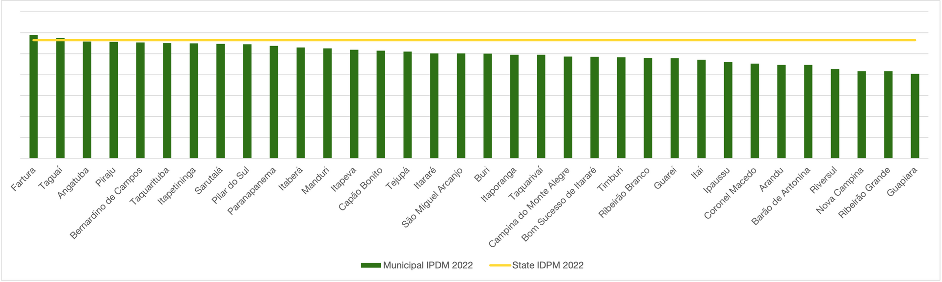
Social and economic conditions reflect persistent development challenges. According to the 2022 IPDM (Índice Paulista de Desenvolvimento Municipal), 32 of the 34 basin municipalities score below the state average on this index that captures wealth, education and longevity. Only Fartura and Taguaí exceed the state benchmark.
Although access to basic education and health services exists in parts of the basin, income levels and municipal economic capacity are generally lower than the São Paulo State average.
In the Upper Paranapanema Basin, agriculture shapes social life and livelihoods, but gaps in income and opportunity reflect broader patterns of rural inequality and limited economic diversification.
IPDM for each municipality in the basin compared to the state average
The basin’s development trajectory has been shaped by diverse cultural groups, successive economic transitions and differing institutional arrangements. Municipalities have followed distinct development paths and display varying public management capacities, making the region heterogeneous rather than uniform.
The region contains archaeological sites, artifacts, settlement patterns, and circulation routes documenting human presence across different periods. These records offer important clues about lifeways, cultural practices, and human-environment interactions, though many remain understudied.
From the 19th century onward, road opening, agricultural expansion, economic cycles, urbanisation, and land tenure changes intensified landscape transformation. These historical trajectories shaped the current configuration and identity of basin municipalities.
The region contains associations, cooperatives, and small producers adopting environmentally compatible practices, including agroecological production, community forestry, and traditional crafts. These local initiatives demonstrate the region's capacity to reconcile conservation and production.
The region has areas of landscape, cultural, and environmental interest, including natural attractions, historical contexts, and rural tourism, ecotourism, and adventure tourism initiatives. This reflects cultural value placed on natural heritage and local traditions.
Data sources:
NEEDS team input (Alexandre - this relates to the book you are editing - is this now publicly available to reference? Otherwise - do you have a preferred way to reference it?
Research insights
xx
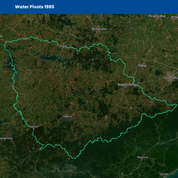
Rapid growth of irrigation
Agriculture in the Upper Paranapanema Basin has become increasingly dependent on the intensive use of natural resources, particularly water.
A key driver of this shift has been the expansion of central pivot irrigation, which has made large-scale, irrigated cropping possible across much of the region.
In the 1980s, there were only three systems operating in the basin. Since then, the number of pivots has grown sharply. Data from the National Water Agency shows that there were around 1,670 systems in 2014, rising to over 2,300 by 2022.
Municipalities with the largest irrigated areas include Itaí, Paranapanema, Itapeva, Itaberá, and Buri.
Growth in commercial irrigation (1985 - 2022)
The number of water pivots has increased significantly since the first ones were installed in the 1980s.
This expansion reflects the growth of export-oriented crops, particularly soybean and maize, and the increasing corporate nature of agricultural production. Installing and operating a central pivot system requires significant capital investment, which is typically beyond the reach of individual family farmers. As a result, irrigation-led modernisation has reinforced the trend of declining family farming alongside the expansion of larger, more capitalised and competitive agricultural operations.
Key insights
- In the 1980s, only three central pivot irrigation systems were operating in the region.
- By 2014, the number of central pivots had increased to approximately 1,670 systems.
- By 2022, this number had surpassed 2,300 systems, indicating very rapid expansion over four decades.
- Municipalities with the largest irrigated areas include Itaí, Paranapanema, Itapeva, Itaberá, and Buri.
Reference publications
Santos, L. L., Graciano, M. C., Araujo, J. C. L., Melo, D. P., & Martensen, A. C. (2023).
Agronegócio e a busca por terra e água: uso do solo, irrigação e estrutura fundiária na Região do Alto Paranapanema – São Paulo.
xx
Declining numbers of family farms and increasing land concentration
In the Upper Paranapanema Basin, the number of family farming establishments has been declining, contributing to a broader process of land concentration. Under Brazilian Law No. 11,326 (2006), a family farmer is defined as a producer who operates no more than four fiscal modules of land, relies primarily on family labour, and derives most household income from activities carried out on the rural property.
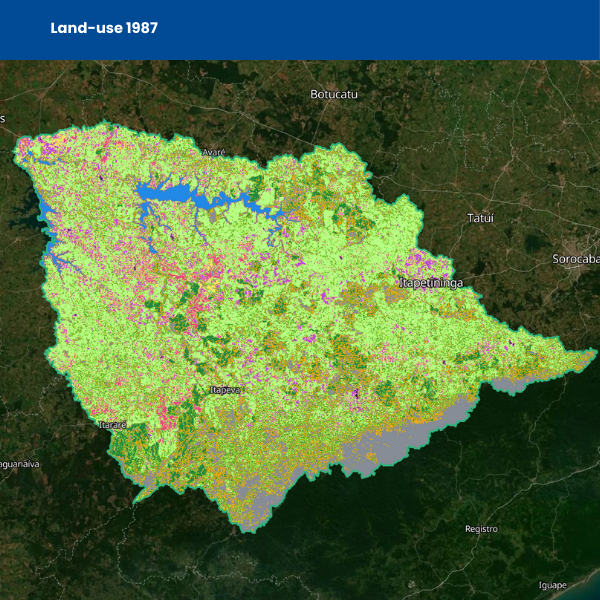
Analysis by Santos et al. (2023) shows that between 2006 and 2017, the total number of family farming establishments in the basin declined overall, despite some short-term fluctuations. Twenty-two municipalities recorded reductions of more than 20%, seven municipalities experienced declines of 10–20%, and a further two municipalities saw losses of 5–10% in the number of family farms. This contraction occurred alongside a significant expansion in the area under intensified agriculture, indicating that agricultural land has increasingly shifted toward larger, more capitalised production units.
Over the same period, Santos et al. document a substantial increase in land dedicated to intensified agricultural systems, with intensified agriculture expanding by approximately 600% between 1987 and 2017, largely replacing pasturelands. This expansion was closely associated with the growth of mechanised and irrigated cropping systems, reinforcing a pattern in which fewer establishments control a larger share of agricultural land. Taken together, these trends show that agricultural production in the basin has increased in area and intensity, even as the number of family farming operations has declined.
Expansion of agriculture (1987 - 2017)
The area of the Basin's land used for agriculture is increasing.
Key insights
Land use: Between 1987 and 2017, land use changed markedly, with agricultural expansion over areas previously dominated by pasture, which were strongly reduced.
Family farming: The number of family farming establishments declined in 31 of the 44 municipalities between 2006 and 2017.
Land concentration: Most municipalities showed medium to high levels of land concentration, with an intensification of this process in about 75% of municipalities between 1995 and 2017.
Reference publications
Santos, L. L., Graciano, M. C., Araujo, J. C. L., Melo, D. P., & Martensen, A. C. (2023).
Agronegócio e a busca por terra e água: uso do solo, irrigação e estrutura fundiária na Região do Alto Paranapanema – São Paulo.
xx
Landowner attitudes to reforestation
With close to a third of Brazil’s land used for agriculture, farmers are critical actors in any large-scale nature recovery effort.
In the Upper Paranapanema Basin, nature recovery such as reforestation is most effective when it is integrated into existing agricultural systems rather than imposed as land set aside from production.
Evidence shows that regulation alone is unlikely to deliver sustained restoration outcomes. Landowners respond more positively when nature recovery is supported by clear legal frameworks, financial incentives, technical assistance, and flexible restoration models such as agroforestry or natural regeneration.
These approaches reduce perceived risk, align restoration with farm productivity, and increase willingness to participate, especially among smaller landholders. Catchment-scale programmes and payments for ecosystem services are particularly important for enabling broader participation and long-term commitment.
Farmers play a central role in nature recovery, but participation depends on incentives, support, and how well restoration fits within existing agricultural practices.
Key insights
- Larger farms, used as a proxy for greater access to capital and resources, are associated with higher levels of forest cover.
- Steeper slopes, which are less suitable for intensive agriculture, are also associated with increased forest retention and regeneration.
- Reliance on punitive policy tools alone, such as fines, is associated with weaker landowner engagement.
- Positive incentives and technical support are linked to improved compliance and more durable restoration outcomes.
Reference publications
Nardy, J. R., Duden, A., Martensen, A. C., Henkens, K., Verweij, P., & Verburg, R. (2025).
The role of farmers’ resources, capabilities and perceptions on reforestation and forest cover in the Atlantic Forest.
Duden, A. S., Verweij, P. A., Martensen, A. C., & Verburg, R. W. (2025).
Drivers of reforestation across land-use sectors in the State of São Paulo